In our modern, hyper-connected era, it often feels as though nowhere on Earth is truly beyond the gaze of technology. Satellites orbiting in the vast expanse above us provide a constant, watchful eye on global activity, particularly when it comes to the movement of commercial ships and aircraft. While it may seem like science fiction, the ability to monitor the entire globe is grounded in a sophisticated blend of cooperative tracking, advanced sensing, and artificial intelligence, representing the latest in satellite surveillance technology.
The Cooperative Tracking Systems
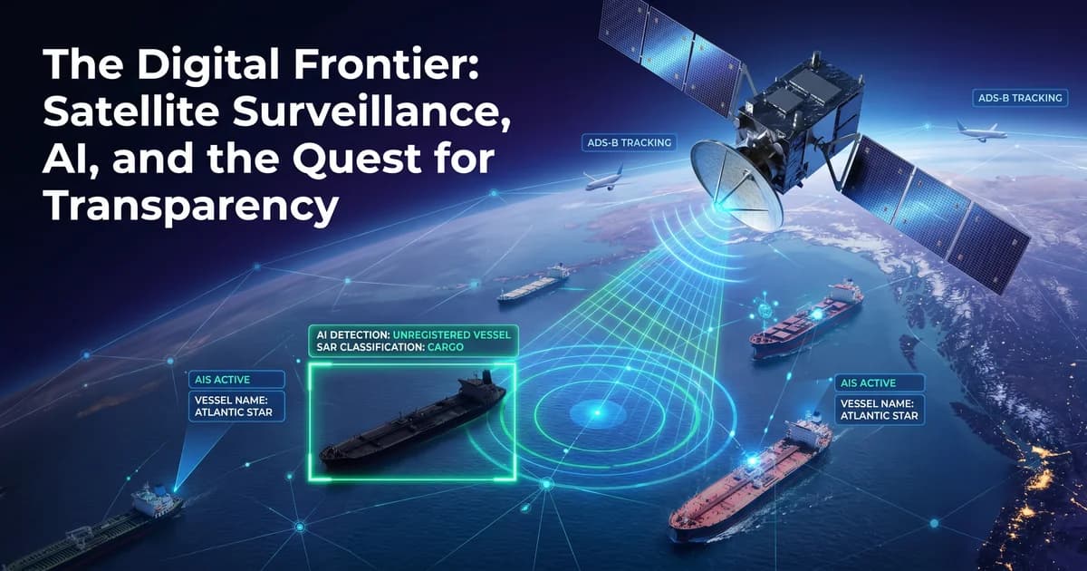
For most commercial ships and planes, being tracked is not a consequence of advanced spy cameras but rather a voluntary act of cooperation. These vessels use automated broadcasting systems designed to improve safety, collision avoidance, and air traffic management.
Maritime vessels utilize the Automatic Identification System (AIS). Originally built for short-range communication between ships, AIS transponders now broadcast identity, position, speed, and course data that can be captured by Low Earth Orbit (LEO) satellites. This is a critical component for maritime security in the USA and global waters. Similarly, aviation relies on Automatic Dependent Surveillance–Broadcast (ADS-B). Aircraft determine their own position using satellite navigation (like GPS) and then periodically broadcast this data, along with their altitude and velocity, to satellite-based receivers. These systems are highly effective because they are automatic, allowing controllers to manage commercial ship tracking systems and flights over large bodies of water or terrain where traditional ground-based radar cannot reach.
The Technology of Detection
When a vessel or aircraft turns off its transponder—a practice often called going dark—it may disappear from commercial tracking apps, but it remains vulnerable to detection by sophisticated spaceborne sensors. Modern surveillance relies on several key technologies to reveal these dark targets.
The table below provides a complete comparison of these technologies:
| Technology | Primary Function | Key Advantage | Limitation |
|---|---|---|---|
| SAR (Synthetic Aperture Radar) | Transmits microwave pulses to illuminate surfaces | All-weather, day-and-night imaging capability | Complex data requires specialized AI analysis |
| EO (Electro-Optical) Imagery | Captures high-resolution, lifelike visual imagery | Positive visual identification of targets | Blocked by cloud cover and darkness |
| VIIRS | Detects night lights on the ocean surface | Identifies illuminated vessels at night | Relies entirely on targets emitting visible light |
Synthetic Aperture Radar (SAR): This is perhaps the most critical tool for maritime security. Unlike optical cameras, SAR is an active sensor that transmits microwave pulses to illuminate the surface of the Earth. Because radar wavelengths can penetrate clouds, smoke, and darkness, SAR provides all-weather, day-and-night imaging. Ships appear as bright spots against the darker, radar-absorbent surface of the ocean, allowing satellites to detect them even without a transponder.
Electro-Optical (EO) Imagery: These are high-resolution cameras that capture lifelike images of the Earth. While limited by cloud cover and darkness, they remain indispensable for the identification of individual objects.
Visible Infrared Imaging Radiometer Suite (VIIRS): This technology detects night lights on the ocean surface, which can help identify illuminated vessels or offshore platforms even in the absence of daytime sunlight.
The Role of AI in Satellite Analysis
The sheer volume of data collected by these sensors is too massive for manual human analysis. To solve this, researchers are integrating Artificial Intelligence (AI) and computer vision. Advanced AI satellite tracking algorithms can automatically scan vast satellite images to identify, classify, and track vessels in real-time.
The latest frontier is onboard processing. Traditionally, images had to be sent to a ground station for analysis, leading to significant latency. New, ultra-efficient AI models are now being designed to run directly on the low-power hardware of the satellites themselves. This allows satellites to detect suspicious behaviour autonomously and alert operators within minutes.
Ultimately, while turning off a radio might hide a ship from common tracking apps, it is nearly impossible to remain invisible to the combined power of SAR, optical sensors, and AI-driven analysis. The invisible eye in the sky is now an inescapable and permanent feature of our modern world.


